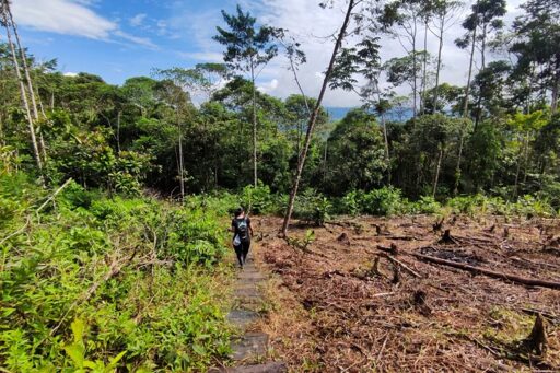
MOCOA, Colombia — From the air, the forests in Putumayo, Colombia’s southwestern Amazonian department, look scarred. Light brown lines snake through the canopy. In the eastern part of Putumayo’s Puerto Guzmán municipality, about 80 kilometers (50 miles) of irregular roads, mostly dirt tracks, cut through the forests, according to the report. Many of them are flanked by bare land where trees once stood. From October 2024 to March 2025, more than 11,000 hectares (about 27,000 acres) of forest have been lost in Putumayo. Colombia’s southwestern department is one of the seven areas featured in a new report documenting recent expansion of deforestation in biodiversity hotspots, driven especially by illicit crops and illegal roads. The areas chosen have higher historical levels of deforestation than other regions in the Colombian Amazon. According to Colombia’s Inspector General’s Office, between October 2024 and March 2025, 88,808 hectares (about 219,400 acres) were deforested across Río Naya, Meta-Mapiripán, Vista Hermosa-Puerto Rico, Triple Frontera (Guaviare), Llanos del Yarí – northern Chiribiquete, Caquetá and Putumayo. The Inspector General’s Office monitored an area of about 3.3 million hectares (8.1 million acres), roughly the size of Belgium. The report, supported by data from the Foundation for Conservation and Sustainable Development (FCDS), a Colombian environmental conservation nonprofit, also highlights 1,107 km (688 mi) of irregular roads associated with forest loss: 782 km (486 mi) were identified by the General Inspector’s Office between March 2024 and March 2025 and are subject to verification by local authorities; the remaining were identified by FCDS…This article was originally published on Mongabay
From Conservation news via this RSS feed
You must log in or # to comment.