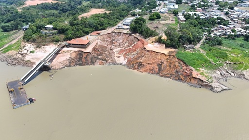
On the afternoon of Oct. 7, 2024, a section of banks along the Solimões River abruptly collapsed at the port of Manacapuru in Brazil’s Amazonas state. The resulting crater was the size of two soccer fields and as deep as 20 meters (65 feet). The collapse killed two people and shut down the port, a regional hub for moving goods and passengers about 160 kilometers (100 miles) upstream from the state capital, Manaus. Investigations later identified an erosion process known as terras caídas — literally “fallen lands” — a natural phenomenon observed along fast-flowing rivers across the Amazon Basin. During the dry season, when water levels drop sharply, riverbanks become tall, exposed walls, particularly vulnerable at river bends, where the waters can more easily dig their base and destabilize the terrain. At Manacapuru, however, human interventions on the riverbank contributed to the collapse. A report by Brazil’s federal geological agency, SGB, obtained by Mongabay shows that the river port was built directly on a bend of the Solimões (the name used in Brazil for the upper stretch of the Amazon River). The document states that walls and embankments further weakened the riverbank, which could no longer support its own weight amid the river’s low water level. “We need to be more careful when choosing where to build ports along Amazonian rivers,” Elton Andretta, a geoscience researcher at SGB, told Mongabay by phone. “Brazil already has satellite imagery and other technologies to monitor Amazonian rivers and identify risks. More conscious use…This article was originally published on Mongabay
From Conservation news via this RSS feed
You must log in or # to comment.