
By: Christopher Tillotson and Prof. Kalyn Rossiter (William and Mary Data Science)
The SAVE America Act (S.1383) would require people to present proof of citizenship in person in order to register to vote in a Federal election. The consequences of the changes from this potential Act are far-reaching, but this piece focuses on potential hardship imposed by requiring proof of citizenship in person. Although the Act applies to all places where people register to vote. This is especially impactful for those that vote by mail, register online, or live in a rural area as the result of the requirement that people register in person. Residents in large counties can be multiple hours away from local election offices, for example. This becomes difficult for people who are not able or for whom it is inconvenient to drive such a distance or take public transportation.
Taking a GIS-based approach to examine the potential impacts of the SAVE America Act illustrates the stakes. Geographic Information Systems (GIS) refers to hardware and software used to analyze and visualize spatial data. GIS is used frequently in urban planning, environmental science, defense, utility management, and many other industries, as a way to work with spatial data to reveal insights that other traditional data science or analysis would not. To provide quantitative proof of the potential effects of legislation, GIS can be used to analyze anything related to spatial ramifications, such as the farthest distances some people would be required to travel to register to vote. Additionally, GIS can provide a convenient visual aid in the form of a map to quickly explain the results of spatial analysis.
In this case, we utilize GIS to examine the potential impacts of the SAVE America Act in Arizona, looking at the distances that residents would have to drive to their county election office (in their county) or motor vehicle division (MVD) office (anywhere in the state) should Congress enact the SAVE America Act. Arizona has geographically large counties relative to other states and has already enacted portions of the SAVE America Act by state statute for state and local elections, requiring specific documentation to register to vote (although Arizona currently allows online submission of these documents). In addition, 11% of the population (~766,000 people) live in rural Arizona according to the 2020 Decennial Census. If the SAVE America Act is put into place at the Federal level, registering to vote would prove difficult for rural Arizona citizens. We calculated the furthest incorporated or census designated place from a county’s election office or MVD, and then found the distance a person would need to drive to get from this place to either office, whichever is closer. These places, county election offices, MVDs, and the distances are visualized on this map:
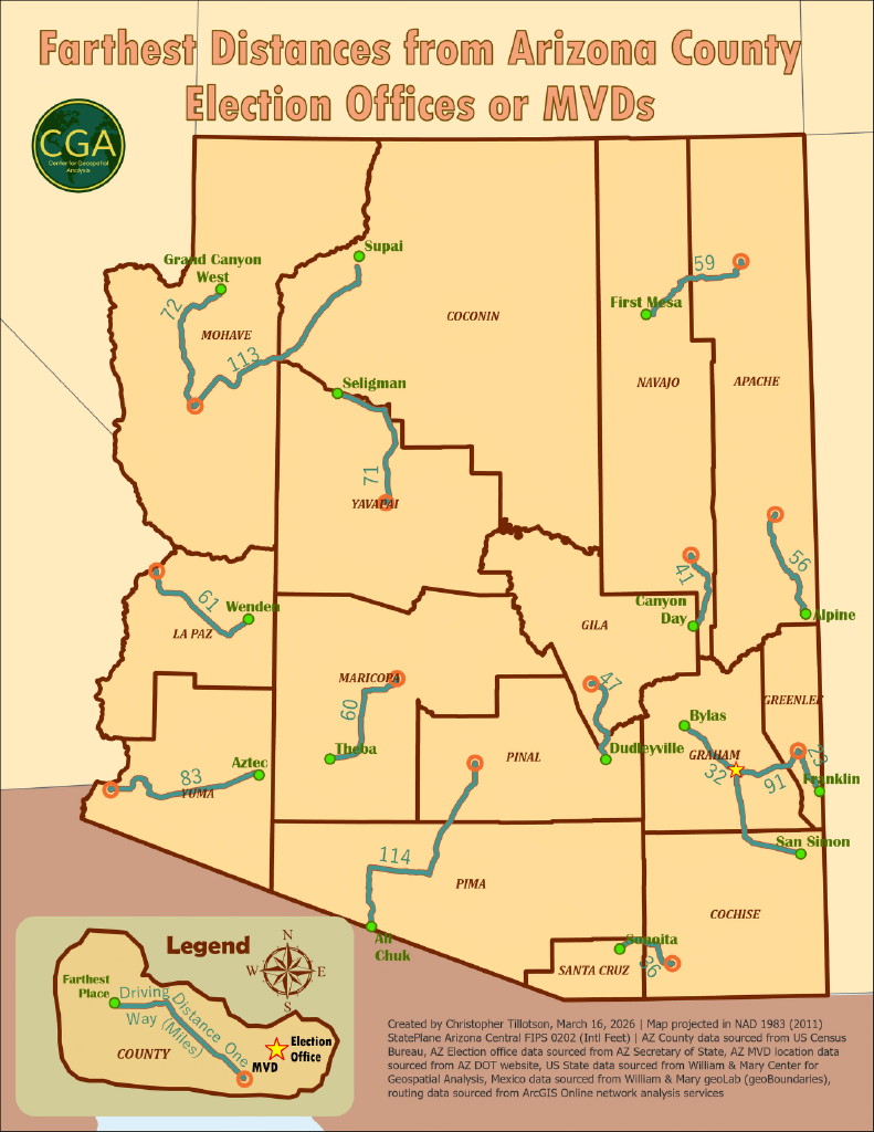
Click to view full size map.
This map demonstrates that residents of Arizona, in the worst-case scenario, must drive 114 miles one way to register to vote. This situation could be ameliorated by opening more county election offices or MVDs, allowing voters to register in a different county’s office, providing employment protection or reimbursement for people who must drive a long distance to register, etc. Arizona currently allows MVDs to accept voter registration materials, provided the resident remembers the proper documentation, which alleviates some of the hardship for urban residents. The immediate result of passing the SAVE America Act is hardship for those who cannot make this trip, especially poorer rural voters and tribal voters, who live far away from the urban centers where county election offices are located.
From State of Elections via this RSS feed
You must log in or # to comment.