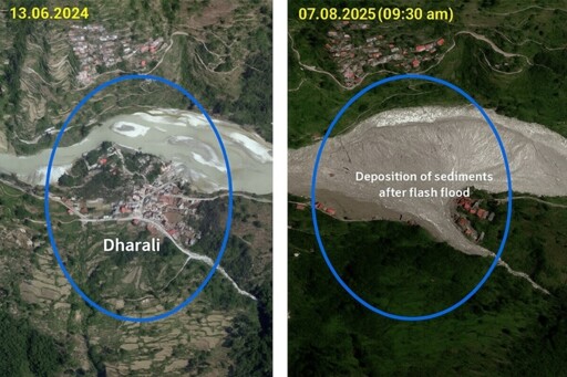
On Aug. 5, a flash flood devastated much of the Himalayan village of Dharali in India’s Uttarakhand state. As of Aug. 17, six people were confirmed dead, while 60-70 people remained missing. The primary cause of the flash flood is still unconfirmed, but experts say that increased construction in the sensitive Himalayan region, despite a history of past floods, worsened the impacts, reports contributor Kavita Upadhyay for Mongabay India. Dharali’s market area, which was covered by 12-18 meters (40-60 feet) of sediment and boulders after the flash flood, has experienced a construction boom in recent decades. Houses, lodges, shops and hotels have sprouted up to accommodate increased tourists as well as pilgrims heading to the nearby, much-revered, Gangotri shrine. “Traditionally, houses in this region were built on stable slopes, away from rivers,” Piyoosh Rautela, a geologist and former executive director at the Uttarakhand State Disaster Management Authority, told Mongabay India. “It was well understood that streams in the Himalaya are not always gentle. They are powerful and have carved out valleys over millennia.” Recent settlements, however, have largely come up in unstable areas along roads and rivers. That’s despite a long history of rivers flooding the area. In June 2013, flooding from the Kheer Gad, the same stream responsible for this year’s disaster, also buried the Dharali market area. After the 2013 flood, the government carried out flood protection work, including building reinforced concrete walls along the banks of the stream, which gave residents a sense of security over future…This article was originally published on Mongabay
From Conservation news via this RSS feed
You must log in or # to comment.