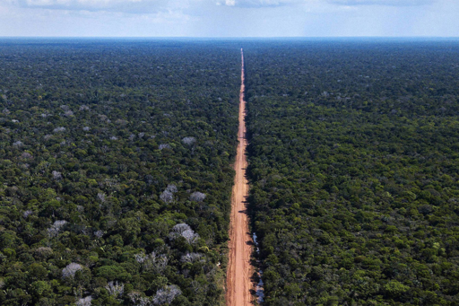
On July 15, Brazil’s Ministry of Environment and Climate Change (MMA) and the Ministry of Transportation reached an “accord” for licensing the notorious BR-319 (Manaus-Porto Velho) highway reconstruction project. The Ministry of Transportation will contract a company to perform a “strategic environmental assessment” (AAE) over eight months to recommend policies to control deforestation, strengthen local communities and “regularize” land tenure in a strip 50 kilometers (31 miles) wide along either side of the highway. Implementation of the plan will be the responsibility of the Civil House (not an environmental agency). The environmental license for the highway reconstruction project is still pending with IBAMA (Brazilian Institute for the Environment and Renewable Natural Resources), the agency within MMA responsible for licensing, and the technical staff in IBAMA’s licensing department have repeatedly questioned the adequacy of the environmental impact study. While considering 50 km is better than the current licensing framework, which basically only considers the roadside itself, it does not come close to reflecting the true impact of the highway reconstruction project. The impact of this federal highway will extend much further, thanks to five Amazonas state roads planned to connect to BR-319 (AM-356, AM-360, AM-464, AM-366 and AM-343) (Figure 1). AM-366 would extend 574 km (357 miles) to the west of BR-319, opening the vast Trans-Purus region to the west of the Purus River to deforesters. Figure 1. Map of BR-319 and planned state side roads. Image courtesy of Fearnside & Graça, 2006. The area along the planned AM-366 and AM-343…This article was originally published on Mongabay
From Conservation news via this RSS feed