Late last month, fires engulfed Namibia’s most visited wildlife reserve – Etosha National Park. An analysis of satellite imagery by Bellingcat has found that more than a third of the park was affected, impacting crucial grazing lands for endangered species, including black rhinos, giraffes and elephants.
Wildfires began on Sept. 22 and swept through the reserve and surrounding areas for five days before an emergency government meeting on Saturday, Sept. 27. After days of extensive burning, the government deployed 500 troops to the region the following day.

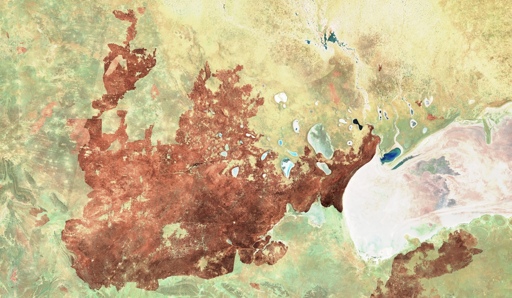
Etosha National Park – SWIR Band Imagery, Sept. 20, 25, 27 and 30. Source: Copernicus
Optical satellite imagery from NASA shows an area of at least 6,000km² was impacted, including agricultural areas beyond the park’s northern border, in the time taken for the government to call an emergency meeting.

Satellite imagery shows the main wildfire rapidly spreading north and east. The development of a second fire, visible in the bottom right-hand corner from the 25th onwards, has not been included. Source: NASA.
The satellite imagery below from Sept. 25 shows burn marks from the fires breaching the park’s northern border, surrounding villages and farmland. Speaking to local media, residents and volunteers said the fire was impossible to extinguish without more support, including fire trucks and helicopters.

Park border outline is breached Sept. 25, with the fire extending further north into farmland by Sept.30. Source: Copernicus.
By Oct. 1, international media reports stated between 7,500 to 8,500 km² of the park had been scorched by the fire. Bellingcat’s analysis of NASA satellite imagery showed at least 7000km² – more than a third of the national park – was affected.
Related articles by Bellingcat
 Investigations
What Can Open Sources Reveal About Beijing’s Deadly Floods?
As a vast area of savanna grassland, fires – often ignited by lightning – are a natural part of the park’s ecosystem, says Prof. Theo Wassenaar, a specialist in biodiversity conservation from Namibia University. However, the scale of this most recent fire is rare.
“Savanna without fires is not a savanna” says Prof. Wassenaar. But “this Etosha fire was notable because it was very large,” he says – “a gigafire (more than 1,000,000 ha)”.
The Namibian Ministry of Environment, Forestry and Tourism did not respond to our request for comment on the time taken to deploy troops to fight the fire.
However, in a public release the Ministry said: “The wildfire crisis in Etosha National Park and surrounding areas poses a significant threat to Namibia’s biodiversity, local livelihood and critical infrastructure.
Origins of the fire
In a post on Facebook, Prime Minister Tjitunga Elijah Ngurare claimed the fires “began on 22 September 2025 in the south-western part of the park due to suspected charcoal production activities on bordering commercial farms.”
NASA FIRMS data matches the Prime Minister’s statement, indicating the fire originated just beyond the park’s south-western borders. As seen below, NASA FIRMS employs a colour classification system to show how long ago an active fire was detected. The yellow square below indicates this latest Etosha wildfire was first detected at 15:25 on Sept, 22.

*NASA FIRMS data from Sept. 22 shows a single yellow square just beyond the park’s borders, marking the earliest fire event that day. Orange and red squares indicate more active fires detected later the same day. Source: NASA FIRMS*.
Further analysis of the yellow square’s location using satellite imagery confirms fire damage occurred on Sept.22, the first day of the event. Weather data from the same day, via Zoom.Earth, also supports this, with the fire’s outward spread aligning with a north-easterly wind direction.
Google Earth imagery also confirmed the presence of a small village and several charcoal kilns near the location identified as the earliest active fire by NASA FIRMS. However, without an extensive ground investigation, the exact cause of the fire cannot be determined.

*Charcoal kilns, blackened earth, and small dark mounds suggest ongoing charcoal production near the yellow square location identified by NASA FIRMS. Source: Google Earth*.
The Ministry did not respond to Bellingcat’s request for comment as to why they suspect the fire began in this location.
Casualties of the Fire
Within days of the fires engulfing large swathes of the park, an image of an injured elephant, badly burned, began circulating on social media.

Posted Sept. 30 to Facebook. Credit: Koos Reyneke.
In response to a flurry of commentators challenging the authenticity of the image, the Minister of Environment, Forestry and Tourism, Indileni Daniel, told reporters at a press conference they could not confirm the image had been taken within Etosha Park, nor could the elephant be confirmed as one of the casualties of the most recent fires. At that time, the only confirmed animal losses – identified by government helicopters monitoring the area – were nine antelopes, one elephant and one injured pangolin.
In an interview with a local news outlet, Network Media Hub, the photographer Koos Reyneke described taking the photo of the injured elephant near a watering hole “just before Charl Marais Dam.” Bellingcat was able to geolocate the image to Ozonjuitji m’ Bari, a waterhole close to the Charl Marais Reservoir.

Top: Facebook post by Koos Reyneke featuring a burned elephant (left). Bottom – YouTube video from 2023. Both geolocated to Ozonjuitji m’Bari, as tagged in Google Maps.
Three termite mounds are visible in both the photographer’s image of the burned elephant posted to Facebook and in a 2023 YouTube video filmed in Etosha Park. Termite mounds can take years to build and may last for hundreds of years. Additional matching features include the horizon line rising to the left, similar bush patterns, and the mud pool in the foreground, which is overflow water from the nearby waterhole.
Shadow analysis using SunCalc – a tool that helps users analyse the position of the sun and shadows to estimate the time an image was taken – lined up with the photographer’s statement that the photos, including that of the injured elephant, were captured at around noon on Sept. 28.

Zooming in on a photo of a jackal with a clearly visible shadow, SunCalc estimated the shadow length to be 42% of the animal’s height. By recreating the sun and shadow positions, SunCal calculated the photo was taken at 11:47 on Sept, 28.
Prime Minister Tjitunga Elijah Ngurare posted on Facebook on Sept.29, stating, “All fires contained / mop-up and monitoring continues.” The Ministry says it will continue conducting aerial surveys by helicopter to assess the extent of the damage. NASA FIRMS continued to detect active fires in Etosha up until Oct. 5.
Bellingcat is a non-profit and the ability to carry out our work is dependent on the kind support of individual donors. If you would like to support our work, you can do so here. You can also subscribe to our Patreon channel here. Subscribe to our Newsletter and follow us on Bluesky here and Mastodon here.
With the unpredictability of social media algorithms making it harder for news outlets to reach audiences consistently, we have also started a WhatsApp channel that you can join to stay updated on our stories.

The post Wildfires Ravage One of Africa’s Largest Nature Reserves appeared first on bellingcat.
From bellingcat via this RSS feed
You must log in or # to comment.